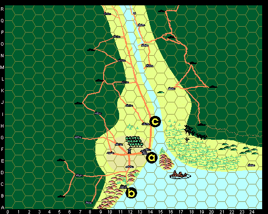
The following map represents the winter (dry) season, when the river is relatively low. In spring, snow melt from the mountains to the north swells the river to encompass the swamps at the mouth of the Great River.
The map above shows larger villages of about 100 people each (blue and black icons) and smaller thorps and plantations of about 50 people each (black icons). The scale is two miles per hex. About half of the colony's population lives in the area shown here. The tan and yellow areas are regularly patrolled; outside these areas, only roads and settlements are regularly patrolled. In the yellow area it is possible to find individual farmsteads, although these are usually stoutly built and may have a palisade.
The tan area marks New Avalon City in its entirety, which includes within its borders three "farming villages" and a garrison. These villages and garrison are not shown in the tightly packed and walled Heart of New Avalon map. The walled quarter shown there is not home to all of the population of New Avalon City. It is, however, home to about 1,500 of that amount. The walled city area is a densly populated place.
In New Avalon City (the tan/gray region) there are:
Within ten miles of New Avalon City, as noted on the map, there are also:
Outside of the region shown on the map:
Site Map | 26 September 99
copyright © 2001 by Michael Moran Alterio, Michael Babriecki, Harry Ching, Stephen Martin, and Donald R. Parrish III (all rights reserved)